 SNELLVILLE – A plan to give residents a network of recreation and transportation trails was approved Monday by council.
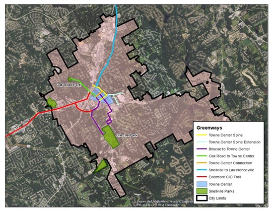
The Greenway Master Plan, which includes four projects city staff deems as essential projects to lay the foundation for a strong, comprehensive network of trails and greenways within the city limits, was approved unanimously.
"The goal of the greenway plan for Snellville is to increase walkability and connectivity in the city," said City Planner Austin Shelton. "In some ways the greenway plan is complimentary to the Towne Center. The goal is to create a vibrant, walkable and human-scaled downtown for the city, and the idea behind the greenway plan is to give Snellville residents more options to walk and bike, without having to first drive to a park across town. Having a walkable downtown is all well and good, but if there is no way to actually walk to downtown then we are missing a big piece of the puzzle.The hope is to connect every part of Snellville to downtown and give residents more choice on how they get around."
Three of these projects will most likely be finalists on Gwinnett County's list of projects that can be feasibly completed by 2040, city officials said. The final project is a Snellville-centric project designed to complement the Towne Center.
The proposed projects are:
Towne Center Spine – a .7-mile trail running parallel to Wisteria Drive along a mostly dry creek bed. This greenway will serve as a "border" more or less to the rear of the Towne Center and will provide another connection from City Hall and the Senior Center to North Road, Scenic Highway and the neighborhoods abutting the north end of Snellville's downtown.
Oak Road Park to T.W. Briscoe Park – This 2.2-mile greenway is meant to connect two of the city's parks to each other and to the Towne Center, providing a mixed recreational and transportation corridor for residents throughout the city.
Snellville to Lawrenceville – 4.5 miles is the approximate distance between the city centers of Snellville and Lawrenceville. The plan is for this greenway to largely follow North Road and Old Snellville Highway, which allows cyclists and pedestrians to travel on quieter roads away from the fast and heavy traffic on Highway 124. It also serves to provide additional connection to Alexander Park, just outside Snellville city limits.
Main Street West / US-78 – At almost 5 miles in length, this is the longest and most ambitious of greenways being planned by the city and Gwinnett County for the area. The goal is to give Snellville and the South Gwinnett area a connection to the existing trail network around Stone Mountain. This is a key connection for the future, as it links the growing Gwinnett County greenway network to the web of trails and greenways in the rest of the Atlanta Metro and beyond.
"The adoption of the Greenway Master Plan is an exciting development for the city and its residents," Shelton said. "But now comes the hard part - making sure that they actually get built."
The first step is to begin work planning where the greenways will go precisely. Then the city will need to identify funding sources. While many of the currently planned greenways will be in right-of-way currently owned by Snellville or the county, there are many locations where trails will run through private property. To this end, the city will begin working to draft legislation that gives both property owners and the city options when it comes to negotiating the location and construction of the trails.
"The county's goal is to have all of their projects completed or at least funded by 2040, but Snellville is committed to beginning work as soon as possible," Shelton said.